EdX

GIS Foundations (edX)

GIS Foundations (edX)

Learn foundations of GIS concepts and geospatial technology to view, understand, query, visualize, and interpret geospatial data to reveal patterns and relationships for effective problem-solving and better decision making.

Class Deals by MOOC List - Click here and see EdX's Active Discounts, Deals, and Promo Codes.

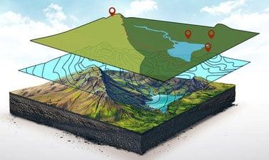
GIS is a framework for gathering, managing, and analyzing data. Using the principles of geographic science, it integrates many types of geospatial data, analyzes their relationships, and organizes them in layers of information for visualization and improved understanding. This course focuses on ESRI’s ArcGIS software, the industry standard. Jack Dangermond, CEO of ESRI, describes GIS as “uncovering meaning and insights from within data.”
Participants in this course will learn GIS concepts, tools, and processing applicable to problems in a variety of fields. The course is designed for self-study with lessons covering GIS applications on real-world problems, and prepares learners for more advanced applications such as 3D GIS and GIS Image Analysis, the two other courses in the GIS Essentials Professional Certificate.
GIS, once an esoteric technology limited to geographers and data scientists, is now available to everyone. Thousands of organizations in virtually every field are using GIS to analyze data, make maps that reveal patterns and relationships, share insights, and solve complex problems of local to global significance.
Verified track learners will receive a one-year ArcGIS Pro license in addition to unlimited course access and a verified certificate.
This course is part of the Geographic Information Systems (GIS) Essentials Professional Certificate.

What you'll learn

  • Use ArcGIS Pro software efficiently
  • Explore, create and analyze geospatial data in ArcGIS Pro software
  • Create and share new GIS data
  • Use ArcGIS geoprocessing tools for data preparation, building workflows and spatial analysis
  • Create informative maps, graphs and charts
  • Perform spatial analyses on points, lines, and polygons data to gain deeper insight into data, pattern and relationship

Syllabus

Week 1: Introduction to GIS

  • What is GIS?
  • History of GIS
  • GIS data types (vector and raster)
  • GIS file types (File Geodatabase, Feature Class, Shapefile, Table, GeoTiff)
  • Coordinate systems (geographic and projected)
  • GIS applications and ArcGIS Pro access

Week 2: Getting started with ArcGIS Pro Software

  • Project set up in ArcGIS Pro
  • Introduction to Geoprocessing tools
  • Introduction to feature class (point, line, polygon)
  • Working with attribute table
  • ArcGIS best practices

Week 3: Spatial Analysis using Geoprocessing tools

  • Point analysis
  • Line analysis
  • Polygon analysis

Week 4: Map Layout and Charts

  • Create your first GIS map
  • Add basic map elements to a map layout (title, scale, north arrow, descriptive text)
  • Add advanced map elements (map grid and overview map)
  • Create charts
  • Format and analyze charts
Go to Class
MOOC List is learner-supported. When you buy through links on our site, we may earn an affiliate commission.

Related Courses

Imagery, Automation, and Applications (Coursera) Coursera
University of California, Davis

Imagery, Automation, and Applications (Coursera)

Welcome to the last course of the specialization (unless your continuing on to the capstone project, of course!). Using the knowledge you’ve learned about ArcGIS, complete technical tasks such raster calculations and suitability analysis. What you will learn:Use the imagery in two different common types of analysis: NDVI and trained classification; Practice with tools to support image analysis using Raster Calculation and Spatial Analyst; Develop a large processing workflow in ModelBuilder; Use products derived from digital elevation models

Jun 17th 2024
4 Weeks
GIS Image Analysis in ArcGIS Pro (edX) EdX
University of Alaska Fairbanks,AlaskaX

GIS Image Analysis in ArcGIS Pro (edX)

Learn fundamentals of remote sensing, image analysis, image processing and its application on real-world problems such as vegetation health, wildfire severity, and flooding. Image analysis is extraction of meaningful information from an image to accomplish a simple task like understanding the landscape or to solve a complex problem like face recognition.

Self Paced
Self-Paced
Essential Epidemiologic Tools for Public Health Practice (Coursera) Coursera
Johns Hopkins University

Essential Epidemiologic Tools for Public Health Practice (Coursera)

In order to make a difference in the health and well-being of a population, we must understand the burden of all problems and conditions that affect the population, as well as how well our efforts to mitigate these problems are actually working. This course provides you with some essential skills and tools that will enhance your ability to describe and understand the health of your community

Jun 8th 2026
4 Weeks
Modellazione digitale 3D: input (POK) Polimi OPEN KNOWLEDGE
Politecnico di Milano

Modellazione digitale 3D: input (POK)

Importare, georeferenziare e gestire, in ambiente CAD, database cartografici e fotogrammetrici. Il programma, di carattere prettamente operativo, si propone di fornire indicazioni pratiche per l’acquisizione e la gestione di cartografia da geoportale, per l’acquisizione e la gestione di dati metrico spaziali acquisiti tramite scansione 3D in ambiente reale, e per la georeferenziazione e integrazione delle informazioni in ambiente CAD.

Available
2 Weeks
Cartography (Esri) Esri
Esri

Cartography (Esri)

Once, only cartographers made maps. Today anyone can. Still, cartographers can teach people to make better maps, just as chefs can show people how to cook better meals. With coaching from experienced cartographers and practical, hands-on exercises using ArcGIS Pro, you'll become a smarter mapmaker, ready to go beyond the defaults and make better maps.

Feb 16th 2022
5-12 Weeks
Spatial Analysis with SAP HANA Platform (openSAP) OpenSAP
SAP

Spatial Analysis with SAP HANA Platform (openSAP)

Today, enterprises and organizations collect and analyze huge volumes of data about everything from products and customers to assets, operations, and transactions. With SAP HANA, you can add a new dimension of intelligence by analyzing spatial data. SAP’s in-memory data management platform not only provides the technology for building geospatial applications, but also geo-content and services, along with a strong partner network. Learn how to leverage SAP HANA’s capabilities for spatial analysis and application development.

Self Paced
Self-Paced
An Introduction to Evidence-Based Undergraduate STEM Teaching (edX) EdX
CornellX,Cornell University

An Introduction to Evidence-Based Undergraduate STEM Teaching (edX)

Learn how to implement evidence-based teaching strategies in your university classroom as well as effective methods for assessing teaching and learning. This course is designed to provide future STEM faculty, graduate students and post-doctoral fellows with an introduction to effective teaching strategies and the research that supports them.

Jun 17th 2024
5-12 Weeks
Introduction to Geospatial Technology Using QGIS (Canvas.net) Canvas Network
Del Mar College

Introduction to Geospatial Technology Using QGIS (Canvas.net)

This course provides a rich introduction to the booming technology field of Geographic Information Systems, known as GIS. The GIS industry is exploding at double-digit employment and income numbers and promises employment opportunities well into the future. Students will learn the fundamentals of GIS and how to build digital maps using open source software that allows free unlimited use for private or commercial applications. All data and software required is included in the course.

No sessions available
No Information
Geohealth: Improving Public Health through Geographic Information (FutureLearn) FutureLearn
University of Twente

Geohealth: Improving Public Health through Geographic Information (FutureLearn)

Explore how spatial data and geographic information systems (GIS) can be used to understand and improve public health. The environment in which we live and work can have a profound effect on our health – an effect that is explored by the emerging field of geohealth. This free online course will introduce you to new developments in geohealth, looking at the latest thinking and methods for using spatial data and geographic information systems (GIS) in health settings.

No sessions available
4 Weeks
Geographical Information Systems - Part 2 (Coursera) Coursera
École Polytechnique Fédérale de Lausanne

Geographical Information Systems - Part 2 (Coursera)

This course is the second part of a course dedicated to the theoretical and practical bases of Geographic Information Systems (GIS). It offers an introduction to GIS that does not require prior computer skills. It gives the opportunity to quickly acquire the basics that allow you to create spatial databases and produce geographic maps. This is a practical course that relies on the use of free Open Source software (QGIS, Geoda).

Jun 8th 2026
5-12 Weeks