Geographical Information Systems - Part 1 (Coursera)

Geographical Information Systems - Part 1 (Coursera)

This course is organized into two parts presenting the theoretical and practical foundations of geographic information systems (GIS). Together theses courses constitute an introduction to GIS and require no prior knowledge. By following this introduction to GIS you will quickly acquire the basic knowledge required to create spatial databases and produce high-quality maps and cartographic representations. This is a practical course and is based on free, open-source software, including QGIS.

Class Deals by MOOC List - Click here and see Coursera's Active Discounts, Deals, and Promo Codes.

If you study or work in the fields of land management or the analysis of geographically distributed objects such as land use planning, biology, public health, ecology, or energy, then this course is for you!
In this first part of the course, we will focus on the digitization and the storage of geodata. In particular, you will learn:

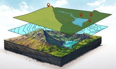
  • To characterize spatial objects and/or phenomena (territory modeling) with respect to their position in space (through coordinate systems, projections, and spatial relationships) and according to their intrinsic nature (object/vector mode vs. Image/raster mode);
  • About the different means used to acquire spatial data; including direct measurement, georeferencing images, digitization, existing data source, etc.);
  • About the different ways in which geodata can be stored - notably, files and relational databases;
  • How to use data modeling tools to describe and create a spatial database;
  • To query and analyze data using SQL, a common data manipulation language.

The second part of this course will focus on methods of spatial analysis and geodata representation. In this section, you will learn:

  • How to describe and quantify the spatial properties of discrete variables, for example through spatial autocorrelation;
  • To work with continuous variables. In particular, we will look at sampling strategies, how to construct contour lines and isovalue curves, and we will explore different interpolation methods;
  • To use digital elevation models and create their derivative products (i.e. slope, orientation);
  • How to evaluate the interaction between different types of geodata through overlay and interaction techniques;
  • How to create effective maps based around the rules of graphic semiology;
  • Finally, we will also explore other, increasingly common, forms of spatial representation such as interactive web-mapping and 3D representations.

Syllabus

Week 1
Digitization – Territorial Modeling: Spatial elements and the characteristics
This first week deals with the first step in digitizing terrain, namely territorial modeling. In this week, we will consider factors such as the scale and theme of interest in order to determine which objects or spatial phenomena should included in the model, and we will also see how the geographic positioning and intrinsic nature (e.g. raster or vector) of these elements factors into how they are characterized in a terrain model.

Week 2
Digitization - Geodata Capture and Documentation
Digital data acquisition involves various techniques including the direct measurement of primary data, the semi-automated vectorization and digitization of spatial objects, or the georeferencing of digital images. In this week’s module we will begin with a lesson on metadata in which we will discuss the processes and rules for documenting a dataset, which are essential for data sustainability, and we will also introduce a case study on participatory GIS in Senegal and Seychelles.

Week 3
Digitization - Automated Capture and Use of Existing Geodata
In this week we will continue to build on the topic introduced last week with automatic vectorization, and we will also review a non-exhaustive list of some important pre-existent data sources that are available for you to access. We will finish with a case study of a Senegal-Mauritania biodiversity project before you will test your knowledge in the first quiz of the module.

Week 4
Storage - Geodata Structure and Organization
In this 4th week, which marks the beginning of the second module of the course devoted to data storage, we begin by reviewing the fundamental aspects of geodata storage and the most common data formats, before tackling the theme of relational databases and data modeling. The week concludes with a lesson on creating databases in the QGIS environment and a case study on the role of GIS in a transport and urban planning project in Senegal.

Week 5
Storage - Data Management with SQL
The SQL language is the preferred vector for access to relational databases, and can be used to search for data meeting certain criteria (conditional queries), to aggregate and calculate statistics on subsets of data (aggregation queries), to combine the results of several queries (nesting and merging), to edit and modify data, or even to manipulate data structure (DDL, DML).

Week 6
Storage - Spatial SQL and NoSQL Databases
While the previous week's lessons dealt with various general aspects of the SQL language, in this week we will learn about SQL queries specifically related to the spatial dimensions and the relationships that characterize geodata (geometric and topological spatial queries). We will also present a brief introduction into the rapidly expanding field of noSQL databases and finish the lesson portion of this module with a case study devoted to bushfire management in sub-Saharan Africa. Finally, this first MOOC on an introduction to geographic information systems will conclude with a second quiz to test your knowledge.

Go to Class
MOOC List is learner-supported. When you buy through links on our site, we may earn an affiliate commission.

Related Courses

Éléments de Géomatique (Coursera) Coursera
École Polytechnique Fédérale de Lausanne

Éléments de Géomatique (Coursera)

Les nouvelles technologies de l’information ont facilité l’accès à de nombreuses bases de données offrant au grand public, mais surtout aux professionnels, une multitude de services. Le domaine de l’information géographique a également suivi ce mouvement en modernisant l’ensemble des supports, des plans, des cartes topographiques et de tous les types de données à référence spatiale. Face au déploiement massif des cartes numériques et des nombreux services basés sur la localisation, il s’agit de rester critique et surtout de développer les capacités nécessaires afin de choisir les outils et jeux de géodonnées adaptés aux besoins professionnels.

Jun 1st 2026
5-12 Weeks
Geospatial Analysis Project (Coursera) Coursera
University of California, Davis

Geospatial Analysis Project (Coursera)

In this project-based course, you will design and execute a complete GIS-based analysis – from identifying a concept, question or issue you wish to develop, all the way to final data products and maps that you can add to your portfolio. What you will learn: create a GIS project proposal; develop a hypothesis for a GIS-based question; complete a data analysis in line with your project objectives; interpret and explain the results you obtained in comparison to your original GIS question and/or hypothesis.

Dec 2nd 2024
5-12 Weeks
Digitizing Higher Education (edX) EdX
University of Texas at Arlington,UTArlingtonX

Digitizing Higher Education (edX)

Explore the impact of digitization on how universities and colleges function administratively and academically. Globally, higher education institutions are grappling with the effects of an increasingly digital world. This course provides an overview of how digitization impacts the economics, administration, academics, and research practices of universities and colleges. Higher education administrators, faculty, staff, and students will benefit from this course by exploring the emerging structure and role of higher education.

No sessions available
5-12 Weeks
Introduction to Geospatial Technology Using QGIS (Canvas.net) Canvas Network
Del Mar College

Introduction to Geospatial Technology Using QGIS (Canvas.net)

This course provides a rich introduction to the booming technology field of Geographic Information Systems, known as GIS. The GIS industry is exploding at double-digit employment and income numbers and promises employment opportunities well into the future. Students will learn the fundamentals of GIS and how to build digital maps using open source software that allows free unlimited use for private or commercial applications. All data and software required is included in the course.

No sessions available
No Information
Cartography (Esri) Esri
Esri

Cartography (Esri)

Once, only cartographers made maps. Today anyone can. Still, cartographers can teach people to make better maps, just as chefs can show people how to cook better meals. With coaching from experienced cartographers and practical, hands-on exercises using ArcGIS Pro, you'll become a smarter mapmaker, ready to go beyond the defaults and make better maps.

Feb 16th 2022
5-12 Weeks
Modellazione digitale 3D: input (POK) Polimi OPEN KNOWLEDGE
Politecnico di Milano

Modellazione digitale 3D: input (POK)

Importare, georeferenziare e gestire, in ambiente CAD, database cartografici e fotogrammetrici. Il programma, di carattere prettamente operativo, si propone di fornire indicazioni pratiche per l’acquisizione e la gestione di cartografia da geoportale, per l’acquisizione e la gestione di dati metrico spaziali acquisiti tramite scansione 3D in ambiente reale, e per la georeferenziazione e integrazione delle informazioni in ambiente CAD.

Available
2 Weeks
Geohealth: Improving Public Health through Geographic Information (FutureLearn) FutureLearn
University of Twente

Geohealth: Improving Public Health through Geographic Information (FutureLearn)

Explore how spatial data and geographic information systems (GIS) can be used to understand and improve public health. The environment in which we live and work can have a profound effect on our health – an effect that is explored by the emerging field of geohealth. This free online course will introduce you to new developments in geohealth, looking at the latest thinking and methods for using spatial data and geographic information systems (GIS) in health settings.

No sessions available
4 Weeks
Spatial Data Science and Applications (Coursera) Coursera
Yonsei University

Spatial Data Science and Applications (Coursera)

Spatial (map) is considered as a core infrastructure of modern IT world, which is substantiated by business transactions of major IT companies such as Apple, Google, Microsoft, Amazon, Intel, and Uber, and even motor companies such as Audi, BMW, and Mercedes. Consequently, they are bound to hire more and more spatial data scientists. Based on such business trend, this course is designed to present a firm understanding of spatial data science to the learners, who would have a basic knowledge of data science and data analysis, and eventually to make their expertise differentiated from other nominal data scientists and data analysts.

Jun 15th 2026
5-12 Weeks
Introduction aux Systèmes d’Information Géographique - Partie 1 (Coursera) Coursera
École Polytechnique Fédérale de Lausanne

Introduction aux Systèmes d’Information Géographique - Partie 1 (Coursera)

Organisé en deux parties, ce cours présente les bases théoriques et pratiques des systèmes d’information géographique. - Il propose une introduction aux systèmes d’information géographique qui ne requiert pas de connaissances préalables en informatique - Il donne la possibilité d’acquérir rapidement les notions de base qui vous permettent de créer des bases de données spatiales et de fabriquer des cartes géographiques - Il s’agit d’un cours pratique qui repose sur l’utilisation de logiciels libres, notamment QGIS.

Jun 1st 2026
5-12 Weeks